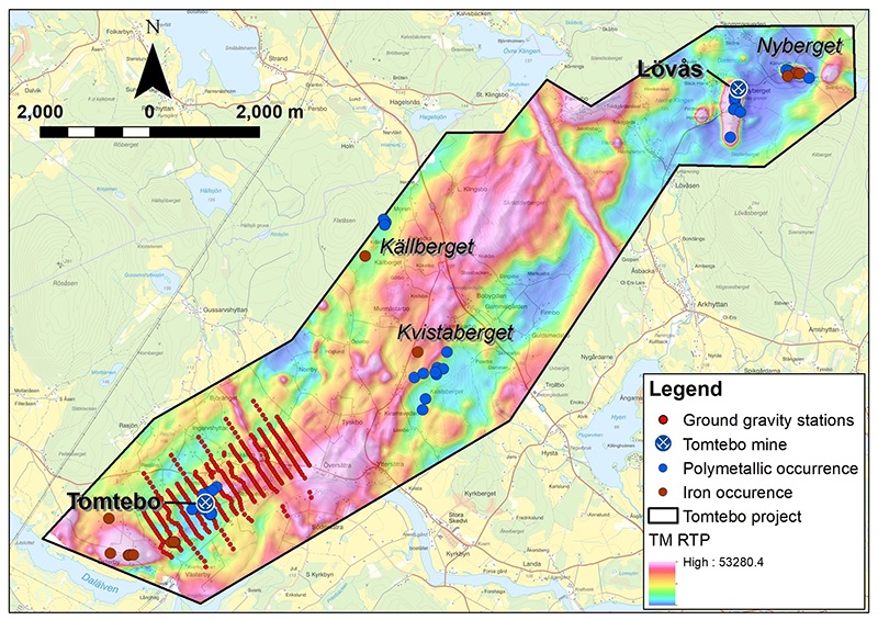
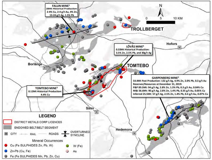
Last week, District Metals (DMX.V) released the results of a ground gravity survey conducted in December last year. Not only did the past-producing Tomtebo polymetallic mine very prominently show up on the survey result, the survey also identified two other high-priority exploration targets. Those two new targets appear to be quite sizeable (with an estimated 29 and 34 million tonnes) which further emphasizes the potential of the Tomtebo project, where a drill program is currently underway.
Perhaps the markets were focusing on easter and the long weekend as there was virtually no reaction to what appears to be an excellent update. Plenty of reason to check in with CEO Garrett Ainsworth to discuss the gravity survey results.
Discussing the gravity survey results with CEO Garrett Ainsworth
Last week, you released an interesting exploration update on the Tomtebo project as you released the results of a ground gravity survey which was conducted a few months ago. Could you perhaps walk us through the results, and why gravity high anomalies are important for the further exploration plans at Tomtebo?
Gravity surveying is used in mineral exploration to determine areas with different density, which is especially important when you are targeting large massive sulphide deposits. In general, large massive sulphide deposits will show a density of greater than 3.2 g/cm3, whereas the surrounding host volcanic or sedimentary rocks will have a density ranging from 2.6-2.8 g/cm3. This difference in density from the gravity survey will produce a gravity high anomaly, which on the Tomtebo Property may be due to polymetallic and/or iron sulphides, or a mafic unit, which all exhibit higher density than the surrounding felsic volcanic rocks that have a density of approximately 2.7 g/cm3.
In order to weed out which gravity high anomalies are better than others we look at other geophysical and geochemical layers of data. Gravity high anomalies will rank higher when they are coincident with isolated magnetic highs, positive conductive responses, or any kind of geochemical anomaly. Much of the Tomtebo Property is covered by a thin veneer of overburden (very little outcrop), so that is where geophysical surveys become very important. Where we find at least two coincident geophysical anomalies (gravity, magnetic, conductivity) the target ranks higher.
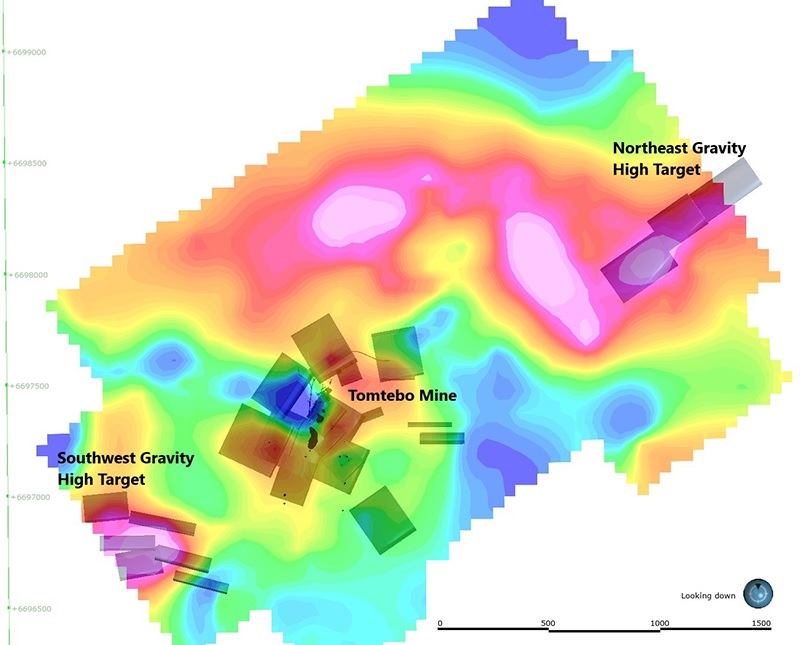
You basically determined three important anomalies of which one coincides very nicely with the historic Tomtebo mine, so that lends some credibility to the two other targets. You also provided some guidance on the size of the anomalies. Could you elaborate on how we should interpret the size of the anomalies?
Yes, it’s important to note that we obtained prove of concept when the gravity survey lit up with gravity high anomalies over the Tomtebo Mine, which has known polymetallic mineralization. That confirmation really provides even more confidence in the gravity high anomalies located along trend of the Tomtebo Mine to the northeast and southwest. It’s also important to note that all three significant gravity high anomalies have similar magnetic high and positive conductive signatures.
Any modeling of geophysical data is conceptual, so any mineral resource estimate can only come from drilling. The software used to model the gravity data creates “plates” with a direction and dip that provide information on how best to drill the target. These “plates” have a volume and a density, so it is possible to create an exploration target with a tonnage.
We know that the gravity high anomalies at the Tomtebo Mine are at least in part associated with polymetallic mineralization, so with that confidence the gravity high anomalies were modeled to a depth of 650 m. The two other gravity high anomalies located northeast and southwest of the Tomtebo Mine were only modeled to depths of 320 to 400 m because they are largely blind targets that start below the ground surface. When you model data deeper you lose resolution at shallower depths, so it’s important to develop a best fit model whereby your shallow targets are as accurate as possible for drill testing.
In summary, all three of the gravity high anomalies could have been modeled to have lower or higher potential tonnages, but a best fit model was generated with the information we have available at this point in time.
The Tomtebo project is often described by District Metals as a VMS/Sedex type deposit. As VMS deposits tend to occur in clusters with a large main zone and a bunch of smaller satellite deposits. Would that model be applicable on the Tomtebo project? Do you think the two gravity anomalies could be those satellite zones?
The polymetallic mineralizing systems in the Bergslagen District are fairly unique compared to typical VMS or SedEx deposits in other districts, but these are effective analogies that help people understand the type of polymetallic mineralization present.
Our Tomtebo Property is between the historic Falun Mine and Boliden’s Garpenberg Mine, which provide the best analogies to the type of polymetallic mineralization we find at Tomtebo. For the most part the historic Falun Mine was just one very large deposit that went down to 600 m, and still has mineralization open in many directions. The Garpenberg Mine has several very large mineralized bodies that are found along a 4.5 km trend to depths of more than 1600 m.
The idea of a large main zone and a bunch of smaller satellite deposits isn’t necessarily applicable to Tomtebo as there is potential to have multiple “main zones”.
What can you do to follow up on the two new zones to figure out if they need to be drill-tested? Or is drilling pretty much the only way to further investigate the targets?
The gravity high anomaly located 1.0 km northeast from the Tomtebo Mine is drill ready with coincident magnetic high and positive conductive signatures. This is a blind target that starts 40 m beneath the ground surface, and there is a thin veneer of overburden over the bedrock, which inhibits prospecting or mapping activities.
The gravity high anomaly located 600 m southwest from the Tomtebo Mine is drill ready with other coincident geophysical anomalies, but we’ll do some ground prospecting beforehand because there are some associated iron sulphide occurrences that daylight at surface. The presence of iron sulphides in this area is important because iron sulphides sometimes coalesce with polymetallic sulphides in the Bergslagen, and we see that at the Tomtebo Mine.
Your gravity survey only covered a 2 by 3-kilometer area. Do you have plans to apply a gravity survey to other (regional) exploration targets?
The gravity high anomalies located northeast and southwest from the Tomtebo Mine are open along strike to the northeast and southwest, respectively. If we have success in confirming polymetallic mineralization at either of these gravity high anomalies, then we’ll probably cover much of the Tomtebo Property with a ground gravity survey.
Conclusion
The results of the gravity survey confirm the importance of Tomtebo as main exploration target, but also shows two large exploration targets to the northeast and southwest of Tomtebo. Preliminary calculations indicate the total size of all three gravity anomalies is about 135 million tonnes. This obviously doesn’t mean District Metals is sitting on 135 million tonnes of mineralized material exceeding cutoff grades for a mining operation, but it does indicate how underexplored the Tomtebo district is.
A maiden drill program is now in full swing and we are looking forward to seeing the first assay results as those will undoubtedly provide the company with valuable information.
Disclosure: The author has a long position in District Metals. District Metals is a sponsor of the website. Please read our disclaimer.